Context
The newly calved berg, designated A-76 by scientists, was spotted in recent satellite images captured by the Copernicus Sentinel-1 mission.
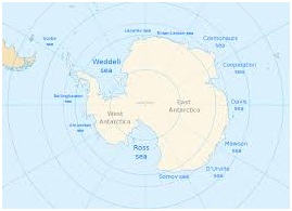
About the iceberg A-76
- A giant slab of ice bigger than the Spanish island of Majorca has sheared off from the frozen edge of Antarctica into the Weddell Sea, becoming the largest iceberg afloat in the world.
- The newly calved berg is designated as A-76 by scientists.
- It was spotted in recent satellite images captured by the Copernicus Sentinel-1 mission.
- Its surface area spans 4,320 square km (1,668 square miles) and measures 175 km (106 miles) long by 25 km (15 miles) wide.
- The enormity of A-76, which broke away from Antarctica’s Ronne Ice Shelf, ranks as the largest existing iceberg on the planet, surpassing the now second-place A-23A, about 3,380 square km (1,305 square miles) in size and also floating in the Weddell Sea.
- A-76 was first detected by the British Antarctic Survey and confirmed by the Maryland-based U.S. National Ice Center using imagery from Copernicus Sentinel-1, consisting of two polar-orbiting satellites.
- The Ronne Ice Shelf near the base of the Antarctic Peninsula is one of the largest of several enormous floating sheets of ice that connect to the continent’s landmass and extend out into surrounding seas.
- Periodic calving of large chunks of those shelves is part of a natural cycle, and the breaking off of A-76, which is likely to split into two or three pieces soon, is not linked to climate change.
Copernicus Sentinel-1 mission
- Sentinel-1 is the first of the Copernicus Programme satellite constellation conducted by the European Space Agency.
- This mission is composed of a constellation of two satellites, Sentinel-1A and Sentinel-1B, which share the same orbital plane.
- They carry a C-band synthetic-aperture radar instrument which provides a collection of data in all-weather, day or night.
- Its activities include sea and land monitoring, emergency response due to environmental disasters, and economic applications.
|