Context
At least eight people have died recently after a cloudburst occurred at the Amarnath Cave Shrine near Pahalgam in south Kashmir.
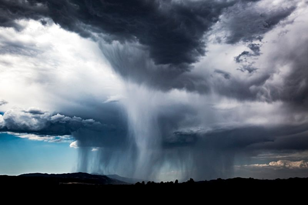
What is a cloudburst?
- A cloudburst refers to an extreme amount of rain that happens in a short period, sometimes accompanied by hail and thunder, and this has a precise definition.
- The India Meteorological Department (IMD) defines it as unexpected precipitation exceeding 100mm (or 10 cm) per hour over a geographical region of approximately 20 to 30 square km.
- It can occur during heavy rainfall with size droplets 4-6 millimetres falling at a speed of 10 metres per second.
- Significant amounts of rainfall such as this can result in floods.
- Basically, all instances of cloudbursts involve heavy rain in a short period, but all instances of heavy rain in a short period are not cloudbursts if they do not fit this criterion.
What causes Cloudburst?
A study published last year studied the meteorological factors behind the cloudburst over the Kedarnath region.
- They analysed atmospheric pressure, temperature, rainfall, cloud water content, cloud fraction, cloud particle radius, cloud mixing ratio, total cloud cover, wind speed, wind direction, and relative humidity during the cloudburst, before as well as after the cloudburst.
- The results showed that during the cloudburst, the relative humidity and cloud cover was at the maximum level with low temperature and slow winds.
- It is expected that because of this situation a high amount of clouds may get condensed at a very rapid rate and result in a cloudburst.
Why do cloudbursts occur in hilly areas?
- The primary reason behind this is rising temperatures which in turn have led to an increase in precipitation across the Himalayas.
- They are more likely to occur in mountainous zones mainly because of terrain and elevation.
- This is because, in hilly areas, sometimes saturated clouds ready to condense into rain cannot produce rain, due to the upward movement of the very warm current of air.
- Instead of falling downwards, raindrops are carried upwards by the air current.
- New drops are formed and existing raindrops increase in size.
- After a point, the raindrops become too heavy for the cloud to hold on to, and they drop down together in a quick flash.