‘Dvorak Technique’: A Cyclone Intensity Estimation Technique
- Posted By
10Pointer
- Categories
Geography
- Published
24th Sep, 2022
-
-
Context
Recently, the American meteorologist Vernon Dvorak passed away. He was credited for developing the Dvorak Technique to estimate the intensities of Tropical Cyclones.
-
Who was Vernon Dvorak?
- Dvorak was an American meteorologist best credited for developing the Dvorak (read as Do-rak) technique in the early 1970s.
- The technique has been upgraded multiple times since then, and after a recent software update in May this year, it has been named the Advanced Dvorak Technique (ADT), coined by the National Hurricane Centre of the National Oceanic and Atmospheric Administration (NOAA).
- The recently updated technique would improve the tropical storm forecasts by many folds as they would have access to sharper and more detailed images than ever before.
- He was bestowed with the United States Department of Commerce Meritorious Service award in 1972.
-
Estimation of Intensity of Tropical Cyclones:
- Tropical cyclones are becoming an increasing menace to society as populations grow in coastal regions.
- Forecasting the intensity of these often-temperamental weather systems can be a real challenge, especially if the true intensity at the forecast time is not well known.
- To address this issue, the development of techniques to accurately estimate tropical cyclone intensity from satellites is a natural goal because observations over the vast oceanic basins are otherwise scarce.
- The most widely utilized satellite-based method to estimate tropical cyclone intensity is the Dvorak technique, a partially subjective scheme that has been employed operationally at tropical forecast centre’s around the world for over 30 years.
- With the recent advent of improved satellite sensors, the rapid advances in computing capacity, and accumulated experience with the behavioural characteristics of the Dvorak technique, the development of a fully automated, computer-based objective scheme to derive tropical cyclone intensity has become possible.
-
What is the Dvorak Technique?
- The Dvorak technique is based on a concept model of the development and decay of the tropical cyclone. Cloud Pattern Recognition Technique (CPRT).
- It was first developed in 1969 and tested for observing storms in the northwest Pacific Ocean.
- It is a statistical method for estimating the intensity of tropical cyclones (TCs) from the interpretation of satellite imagery.
- It is based on a “measurement” of the cyclone’s convective cloud pattern and a set of rules.
- It makes use of both, the longwave Infrared, visible imagery and temperature measurements from geostationary satellites. During day time, images in the visible spectrum are used while at night, the ocean is observed using infrared images.
- In this methodology, available satellite images obtained from polar-orbiting satellites are used to examine the features of the developing tropical storms (hurricanes, cyclones and typhoons).
- From the satellite images, the technique helps forecasters do pattern recognition from the observed structure of the storm, locate its eye and estimate the intensity of the storm.
- Although it cannot help to make any predictions, to measure wind or pressure or any other meteorological parameters associated with the cyclone. But it is a guide to estimating the storm’s intensity and possible intensification, which is crucial for local administration in planning evacuation measures for coastal or other nearby residents.
|
Tropical Cyclones
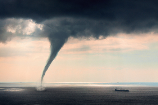
- Tropical cyclones are violent storms that originate over oceans in tropical areas and move over to the coastal areas bringing about large-scale destruction caused by violent winds, very heavy rainfall and storm surges.
- Tropical Cyclones are one of the most devastating natural calamities in the world.
- Tropical cyclones originate and intensify over warm tropical oceans. The conditions favourable for the formation and intensification of tropical storms are:
- Large sea surface with a temperature higher than 27° C.
- Presence of the Coriolis force.
- Small variations in the vertical wind speed.
- A pre-existing weak low-pressure area or low-level-cyclonic circulation.
- Upper divergence above the sea level system.
- The ‘Eye’ of a Tropical cyclone:
- The eye is a region of mostly calm weather found at the centre of strong tropical cyclones. The eye of a storm is usually circular and typically 25–40 miles (40–65 km) in diameter.
- It is surrounded by the eyewall, where the most severe weather of a cyclone occurs. The cyclone's lowest barometric pressure occurs in the eye, and can be as much as 15% lower than the atmospheric pressure outside of the storm.
|
-
Why is Technique still Widely in Use?
- In the 1970s, the means to observe oceans were very few as compared to land-based meteorological observations.
- Even today, with improved land-network meteorological observation, the situation hasn’t improved much and it still relies upon either in the form of taking manual observations, installing automatic weather stations or automatic rain gauges.
- There are many regions across the four oceans that have not been fully examined with meteorological instruments.
- Ocean observations are mostly taken by deploying buoys or dedicated ships, but the number of observations from the seas is still not sufficient across the world.
- This is the reason for meteorologists have to depend more on satellite-based imageries, and later combine it with the available ocean data at the time of forecasting the intensity and wind speed of the tropical cyclones.
- Significance: The Dvorak technique has undergone several advancements since its inception. Even in the present day, when forecasters have access to several state-of-the-art tools like model guidance, animations, artificial intelligence, machine learning and satellite technology, it is the advanced versions of the Dvorak technique that continues to be widely used.
-
Nomenclature of Tropical Cyclones:
- The naming of tropical cyclones is a recent phenomenon. The process of naming cyclones involves several countries in the region and is done under the aegis of the World Meteorological Organization (WMO).
- For the Indian Ocean region, a formula for naming cyclones was agreed upon in 2004. Eight countries in the region - Bangladesh, India, Maldives, Myanmar, Oman, Pakistan, Sri Lanka and Thailand - all contributed a set of names which are assigned sequentially whenever a cyclonic storm develops.
- Hudhud, Titli, Phethai, Fani, Vayu and Amphan are among the names of cyclones in the Indian Ocean region.
-
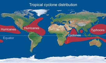
Different terminology is used for this weather phenomenon depending on the location:
- They are given many names in different regions of the world – eg. they are known as Typhoons in the China Sea and the Pacific Ocean;
- Hurricanes in the West Indian islands in the Caribbean Sea and the Atlantic Ocean;
- Tornados in the Guinea lands of West Africa and southern USA.;
- Willy-willies in north-western Australia;
- Tropical Cyclones in the Indian Ocean.