Karbi Anglong peace accord: Rengma Nagas demand autonomous district council
- Posted By
10Pointer
- Categories
Polity & Governance
- Published
11th Jun, 2021
-
-
Context
The Rengma Nagas in Assam are demanding an autonomous district council amid a decision by the Central and the State governments to upgrade the Karbi Anglong Autonomous Council (KAAC) into a territorial council.
-
Background
- The development came on the proposed plan of the Government of India and Assam to finalise Karbi-Anglong Autonomous Territorial Council.
- Karbi-Anglong Autonomous Territorial Council is not acceptable for Rengma Nagas as it alienates their ancestral land in Assam.
-
Analysis
Who are Rengma Nagas?
- Rengma Nagas are found in the states of Assam and Nagaland. The Naga tribe is further divided into Eastern Rengma and Western Rengma.
- They are considered experts in terrace cultivation.
- Important festival: Their harvest festival is called Ngada. Ngada Festival is the greatest and most important festival of Rengma Nagas.
- Rengma are the signatories of the Simon Commission of January 16, 1929.
- Population: 62,951 (2011 Population Census of India)
- In 2014, over 3,000 people from Karbi and Rengma Naga tribes were rendered homeless due to violent clashes that broke out between KPLT and Rengma Naga Hills Protection Force (RNHPF).
-
What are the arguments made by Rengmas?
- In a statement, the Naga outfit stated that the proposal to create Karbi-Anglong Autonomous Territorial Council (KAATC) in Karbi Anglong, is an agreement to appease the six rebel outfits – Karbi Longri North Cachar Hills Liberation Front (KLNLF), People’s Democratic Council of Karbi Longri (PDCKL), United People’s Liberation Army (UPLA) and three factions of Karbi People’s Liberation Tiger (KPLT).
- However, historically nothing is far from the “truth” and no authority should go far enough to override the interests of the Rengma Nagas who are the legitimate owner of the land under the questionable proposition, it contended.
|
Points highlighted
- Rengmas were the first tribal people in Assam to have encountered the British in 1839, but the existing Rengma Hills was eliminated from the political map of the State and replaced with that of Mikir Hills (now Karbi Anglong) in 1951.
- The historical record of Rengmas who have been living in the Rengma Hills of Assam (now changed to Karbi Anglong) have been distinctly documented even before the advent of the British in the area.
- During the Burmese invasions of Assam in 1816 and 1819, it was the Rengmas who gave shelter to the Ahom refugees.
- The Rengma Hills was partitioned in 1963 between Assam and Nagaland at the time of creation of Nagaland State and the Karbis, who were known as Mikirs till 1976, were the indigeneous tribal people of Mikir Hills.
- “Thus, the Rengma Hills and Mikir Hills were two separate entities till 1951. Karbis have no history in the Rengma Hills. People who are presently living in Rengma Hills are from Assam, Arunachal Pradesh and Meghalaya.
- They speak different dialects and do not know Karbi language of Karbi Anglong,”.
|
-
What is Karbi insurgency?
- The Karbi insurgency — for a separate state of Karbi Anglong and North Cachar Hills — is one of the several insurgencies that Assam has faced over the years, apart from the Bodoland movement and the one led by ULFA to demandsovereignty for Assam.
- The Karbis racially belong to the Mongoloid group and linguistically to the Tibeto-Burman group.
- Karbi Anglong, the largest district in Assam, comprises various tribal and ethnic groups — Karbis, Bodos, Kukis, Dimasas, Hmars, Garos, Rengma Nagas, Tiwas, and Man (Tai Speaking). Apart from these groups, a lot of non-tribals also reside in the hilly district.
- It is an autonomous district under the Sixth Schedule of the Indian Constitution and located in central Assam.
- Spread across an area of 10,434 sq km, Karbi Anglong is geographically divided into two parts — East Karbi Anglong (EKA) and West Karbi Anglong (WKA) — with its administrative headquarters located at Diphu town in EKA.
-
What are Autonomous District Councils?
- The Sixth Schedule consists of provisions for the administration of tribal areas in Assam, Meghalaya, Tripura and Mizoram, according toArticle 244 of the Indian Constitution.
- Passed by the Constituent Assembly in 1949, it seeks to safeguard the rights of tribal population through the formation of Autonomous District Councils (ADC).
- As of now, 10 autonomous councils exist in Assam, Meghalaya, Tripura and Mizoram. The specified tribal areas are the North Cachar Hills, Karbi Anglong and the Bodoland Territorial Area in Assam.
- The Karbi Anglong Autonomous Council has 26 seats and elections are due in 2022.
- ADCs are bodiesrepresenting a district to which the Constitution has given varying degrees of autonomy within the state legislature.
- The governors of these states are empowered to reorganise boundaries of the tribal areas.
- In simpler terms, she or he can choose to include or exclude any area, increase or decrease the boundaries and unite two or more autonomous districts into one.
- They can also alter or change the names of autonomous regions without a separate legislation.
|
Regional Councils
Along with ADCs, the Sixth Schedule also provides for separate Regional Councils for each area constituted as an autonomous region.
|
-
What are the Civil and judicial powers of ADCs?
- The ADCs are empowered with civil and judicial powers, can constitute village courts within their jurisdiction to hear trial of cases involving the tribes.
- Governors of states that fall under the Sixth Schedule specifies the jurisdiction of high courts for each of these cases.
- The councils are also empowered to make legislative laws on matters like land, forests, fisheries, social security, entertainment, public health, etc. with due approval from the governor.
- The roles of the central and state governments are restricted from the territorial jurisdiction of these autonomous regions.
- Also, Acts passed by Parliament and state legislatures may or may not be levied in these regions unless the President and the governor gives her or his approval, with or without modifications in the laws for the autonomous regions.
-
Why India’s northeast is so conflicted?
- Lack of basic services: Years after independence, the states in the NER still lack basic services, including health and education, occasionally receiving news coverage highlighting the human rights violations that have affected the civilian population during the years of conflict.
- Run for identity: The region witnesses a complex field for the contestation of identities, land sovereignty, and conflict.
- Poor connectivity: The landlocked Northeast region is connected to the rest of the country through the barely 20-kilometre wide Siliguri Corridor that is supplemented by air routes and, in the recent decades, land routes through Bangladesh. Not only is the Northeast poorly connected with the rest of the country but is also internally disarticulated.
- Difficult terrain: The inability of most states in the region to plug persistent gaps in infrastructure is part of a larger development deficit. Their economies are constrained by ‘landlockedness’, difficult terrain, dense forest cover, a lack of physical connectivity, and longstanding insurgencies.
- Hindered developmental activities: Geography not only hinders the developmental efforts of the state but also obstructs the ability of people to access education and healthcare facilities, and markets.
|
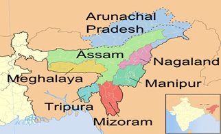
India’s North Eastern region (NER)
- India’s North Eastern Region (NER) includes the states of Assam, Arunachal, Manipur, Meghalaya, Mizoram, Nagaland, Pradesh, Sikkim and Tripura.
- Together, they represent a distinct geographic, cultural, political, and administrative entity.
- The area, which is part of the Eastern Himalayas, is also of geo-strategic significance as it shares 90% of its borders with four countries – Bangladesh, Bhutan, Tibet Autonomous Region/China and Myanmar, and also with Nepal – and is connected to India by a narrow piece of land called the Siliguri corridor, sometimes referred to as the ‘Chicken’s neck’.
|
-
Conclusion
To conclude, various conflicts and issues in India’s northeast “represent durable challenges to the integrative and accommodative capacity of Indian democracy”. Thus, the Government’s focus should be on the promotion of the peaceful coexistence of conflict affected ethnic groups through strengthened democratic processes.