Kerala stares at flood havoc for third straight year
- Posted By
10Pointer
- Categories
Environment
- Published
11th Aug, 2020
-
-
Context
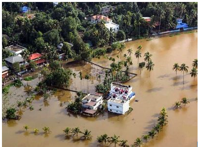
Incessant rain and strong winds swept across several parts of Kerala amid predictions of heavy or very heavy rain in many others, as the coastal state faces its third consecutive year of floods.
-
Background
- Due to the incessant rains in the State, all the dams have been filled with water. This is the third consecutive year when Kerala is facing a flood disaster.
- On the west, the coastal areas are being battered by a rough sea. On the east, along the fragile high ranges, sustained heavy rainfall in the last two days has set off innumerable high- and low-intensity landslides.
- And the midlands have been flooded by the rivers that have been bloated far beyond their banks by both the intense spells and the high-velocity waters dumped on them by the landslides.
- The state was bound to receive heavy rainfall due to the low pressure formed in the Bay of Bengal.
- But even the experts could not forecast this much rainfall during a short period.
- The extremely heavy rainfall in the Western Ghats led to floods and triggered landslides.
-
How worsening the flood in India is?
- India’s summer monsoon has always been variable and has often precipitated floods, especially in the basins of the great Himalayan Rivers.
- But a combinationof global warming, unplanned urban growth, and environmental degradation is increasing flood risk in India.
- The extreme precipitation events are on the rise in large parts of India, especially multi-day deluges that lead to large-scale floods.
- Warmer temperatures are also speeding up glacier melt in the Himalayas, which is projected to increase flow rates in the Ganges and Brahmaputra Rivers.
- As importantly, destruction of mountains and hills, as well as development on floodplains and marshes, are exacerbating risk, as seen in historic floods in the southern state of Kerala.
- Those floods were caused by extreme rainfall and mismanagement of dam reservoirs, but mining and construction in the Western Ghats, a major hill range, contributed to damaging landslides.
|
Floods
- A flood happens when water overflows or soaks land that is normally dry. Flooding is caused by the inadequate capacity within the banks of the rivers to contain the high flows brought down from the upper catchments due to heavy rainfall.
- Floods during monsoons are as common in the centre of India as much as they are in coastal states.
- Uttar Pradesh and Bihar are prone to bad monsoons and saw the worst of it in the catastrophic floods last year that affected an estimated 40 million people.
- Flooding is accentuated by erosion and silting of the river beds, resulting in a reduction of the carrying capacity of river channels
- earthquakes and landslides leading to changes in river courses and obstructions to flow
- synchronization of floods in the main and tributary rivers
- retardation due to tidal effects
- encroachment of floodplains
- Haphazard and unplanned growth of urban areas.
- Some parts of the country, mainly coastal areas of Andhra Pradesh, Orissa, Tamil Nadu and West Bengal, experience cyclones, which are often accompanied by heavy rainfall leading to flooding.
|
|
A look at numbers
- The number of floods in India rose to 90 in the 10-year period from 2006 to 2015, up from 67 in the 10 years between 1996 to 2005, according to the UN Office for Disaster Risk Reduction.
- Globally, floods made up 47 per cent of all climate-related disasters from 2006 to 2015, up from 40 per cent in the 1996-2005 period, says the agency’s 2015 report.
- Overall flood mortality fell in those two decades, except in a handful of countries, including India, where death tolls continued to rise, from 13,660 from 1996 to 2005, to 15,860 from 2006 to 2015.
- A 2017 global analysis by the World Resources Institute said that India has the most GDP exposed to river flooding ($14.3 billion), a number that could rise 10-fold by 2030 as the economy continues to grow.
|
-
Why Kerala being the special case?
- Kerala is a state on the south-western, Malabar Coast of India. Kerala, which lies in the tropic region, is mostly subject to the type of humid tropical wet climate experienced by most of Earth’s rainforests.
- The Indian state of Kerala receives some of India’s highest rainfall during the monsoon season.
- Kerala is ecologically sensitive owing to the geography and topography of the region.
- Kerala has a total 5,924 quarries, an average of six quarries per panchayat, of which 3,332 are in the ecologically sensitive zones identified by Gadgil.
- In sum, 56% of the quarries are on fragile spots in the Western Ghats, making them prone to landslides.
- Practically, the entire state is drainage medium for run-off from the Western Ghats towards the Arabian Sea.
- As a result, the state has a dense network of rivers linking the hills to the sea.
- While rain is abundant across the state, the coastal regions, especially in northern Kerala, rather than the Western Ghats that receive the bulk of the rainfall during the monsoons.
- Because of this, Kerala’s rivers are spared the flooding risks associated with rivers swollen with heavy volumes of run-off.
-
Why Kerala is prone to floods?
- Massive construction: Massive constructions have destroyed the slope of the hills and changed the course of rivers (Panamaram, in Wayanad). All of its tributaries are reclaimed now, and the water has nowhere to go.
- Soil-piping: Soil-piping is a major cause for the landslides witnessed in these places and the high ranges of Kerala will likely be worst hit if this continues.
- Also known as 'tunnel erosion', soil piping is the subsurface erosion of soil caused by percolating waters to produce pipe-like conduits below the ground, especially in non-lithified earth materials.
- Fragmentation of forests: The fragmentation of forests is also reflected in human-animal conflict that has been on a rise.
- Unrestricted mining: Unrestricted mining operations in both places have contributed to environmental degradation.
- Rise in temperature: The district has also witnessed a change in temperature of 2-3 degrees, that otherwise happens over centuries, over a short span of years.
How the floods brought to light the existence of illegal stone quarries?
- In 2011, the Gadgil Committee put together a bunch of recommendationsto the central government about ecologically-fragile regions in the Western Ghats.
- They found the highest number of vulnerable zones in Kerala and cited several reasons for them being classified as such.
- Some reasons for its vulnerability were geographical, a challenge posed by its position amidst the Ghats.
- Many other causes – quarrying, mining, illegal repurposing of forests, and high-rise building constructions – were man-made, controllable factors that the state chose to brush aside.
- The flooding has definitely brought to light the existence of illegal stone quarries or a large number of unauthorised constructions on river beds.
- In this sense, it is definitely a man-made calamity where intense rainfall and human intervention have made it a serious disaster.
- The quarrying Prof Gadgil refers to, along with deforestation in the region, has intensified the horrific landslides the state is witnessing.
-
Is it a result of poor planning of disaster management authority?
- One of the most severely affected areas is Ernakulum in Kochi, along the Periyar River, into which excess water from the Idamalayar dam was drained.
- It is claimedthat authorities waited till the water level in the Idamalayar reservoir reached its capacity of 169 feet, and had it been opened sooner, would likely have spared the massive evacuation efforts in the vicinity.
- The authorities made a mistakeby opening all four gates of the dam at once, flooding the underlying regions at a much faster rate than expected.
- It is clearly the result of poor planning by the disaster management authority.
-
What about weather predictions?
- Time and again, data and statistics on weather events have been used to fuel many arguments linking freak weatherevents, like the floods in Kerala, and climate change.
- Leading experts are wary about drawing the same conclusions; they state that weather data is complex, and particularly so in a tropical country like India.
- A climate studyspanning 1950-2015 looks at extreme rain events in central India, which the researchers say happens three times as frequently in recent times as it did in 1950.
- These have also intensified, because westerly winds that move over an increasingly-warmer Arabian Sea carry surges in moisture with them as they move into the subcontinent during monsoons.
- Predicting such events can be done two-to-three weeks ahead, at best.
-
What’s adding to the challenges?
- Unplanned urbanization is already increasing flooding. India added 90 million peopleto its urban population between 2001 and 2011, and will add 416 million more by 2050.
- In addition, sprawling Indian cities have been building on wetlands and expanding into floodplains.And urbanization itself may be affecting rainfall patterns.
- Urban heat islands could be intensifying thunderstorms over Mumbai.
-
What can India do to reduce its flood risk?
- Eco-system flood management approach: New ecosystem-based flood management approaches being promoted by international agencies have yet to catch on in India. That includes planning cities with ponds and permeable surfaces, restoring wetlands and forests, and regulating development in floodplains and hills.
- Strict policies: The future remains bleak for Kerala with the villages adjoining the Western Ghats being located at a slope of +30 degree angle, no scientific mining policies in place and massive mining operations going on in the high ranges. The state needs strict policies and rules in place.
- Eco-friendly living: The state needs to embrace eco-friendly living and ensure minimum exploitation of our land.
- Better management: Better preparedness and quick response is the need of the hour. Dam management needs to be more scientific during monsoons
- Community involvement: A strong bond within the community is essential in emergency situations
- Protection of wetlands: There is need to protect wetlands and water channels to avoid floods
- Ban on mining: Mining operations should be banned in ecologically fragile areas.
- Responsible construction model: There's a need to develop responsible house construction modules.
Conclusion
Tropical countries like India evolve differently than countries in the West, which have larger land area and time periods over which to observe and predict a given weather event. Average temperatures throughout Southeast Asia were seen rising, and rainfall growing more erratic, particularly in India. These weather changes will continue to shadow us over coming decades. States such as Kerala are at a substantial risk of flood-related damage in the century to follow. The time for change is now but the question is, will Kerala learn from its mistakes?