Current Affairs
Explained

The world’s wettest place is witnessing a decline in rainfall

  • Posted By
    10Pointer
  • Categories
    Geography
  • Published
    24th Feb, 2021
  • Context

    Sub-topic

    • GS-I: Geographical features and their location-changes in critical geographical features (including water-bodies and ice-caps) and in flora and fauna and the effects of such changes.

    A recent analysis of 119 years of rainfall measurements at different rain gauge stations across North East India, has revealed a decreasing trend in summer rainfall since 1973, including in rainy Meghalaya, reputed for hosting the world’s wettest place.

  • Background

    • Parts of India, especially Northeast India, one of the wettest places on the Earth, are facing a severe impact of the climate crisis with reduced rainfall and increase in dry, or no rain, and heavy rain days.
    • The monsoon, which generally begins in June and retreats by September, delivers around 70% of India’s annual rainfall.
    • The monsoon is key to replenishing reservoirs, groundwater and addressing water shortages.
    • However, the current study has shown significant decreasing trends in Meghalaya, where Cherrapunji is known as one of the places with the highest precipitation globally.
      • Climate change is bringing erratic weather—flood and drought, sometimes in the same area (for example-Kerala (2018).
      • The monsoons now bring less rain in total, while the demand for water increases as the population, economy, and industry grows.
      • The rains come in increasingly violent deluges, but with little storage options, most of the rainwater is lost as run-off.
  • Analysis

    Assessing North East India on the rainfall track

    • North East India is mostly hilly and is an extension of the Deccan plateau.
    • The region is highly sensitive to changes in regional and global climate.
      • Northeast India has the highest vegetation cover in India and included in 18 biodiversity hotspots of the world, indicating the importance of the region in terms of its greenery and climate-change sensitivity.
    • Pre-monsoon and monsoon are the rainy seasons of North East India.
    • Rain-bearing summer air currents (the Bay of Bengal branch of monsoons) that move north from Bangladesh’s hot and humid floodplains hit the funnel-shaped relief of the Meghalaya hills with deep valleys and gorges.
    • The steep parallel mountains (Garo, Khasi and Jaintia hills) in Meghalaya block the movement of the clouds to the north; they are squeezed in through the gorges and then forced to ascend the steep slopes and shed most of their rainfall in the region.

    About Cherrapunji

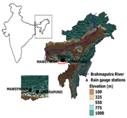
    • Cherrapunji, known to locals as Sohra, is located in the East Khasi Hills in the Indian state of Meghalaya.
      • Sandwiched between Assam in the north and Bangladesh in the south, Meghalaya is a part of the Indo-Burma biodiversity hotspot--one of the most threatened biodiversity hotspots in India after the Himalayas--due to rapid resource exploitation and habitat loss.
      • The hills of the eastern sub-Himalayas- Garo, Khasi and Jaintia, run through most of Meghalaya, and the rest of the landscape is a high plateau.
    • Cherrapunji was declared the wettest land-based location on Earth after it receive an average of 11,872 mm in annual rainfall  — more than 10 times India's national average (of 1,083 mm). 

    What is meant by ‘wettest’?

    • When it comes to describing locations on planet Earth in terms of “wet”, some clarifications are needed.
    • Here, the average annual precipitation is addressed– i.e. rainfall, snow, drizzle, fog, etc. – measured in mm (or inches).

    Reasons for the torrential rains

    • The reason for these torrential rains is complex, but, essentially, monsoon clouds from the Bay of Bengal fly over hundreds of kilometers of open, relatively flat terrain to reach Cherrapunji.
    • Once the clouds reach Cherrapunji, they are faced with the rather steep rise of the Khasi Hills, and in order to rise with the hills, they must first dump much of their moisture.
    • Cherrapunji's location between the Bay of Bengal on one side and the Khasi Hills on the other justifies the heavy rainfall it receives.
    • Moisture from the Arabian Sea also brings heavy rainfall to Mahabaleshwar.

    Other Important locations:

    Beyond northeastern India, there are several other locations on Earth that experience over 10 meters (32.8 feet) of annual precipitation.

    • The town of Tutunendo, Colombia, experiences an average of 11,770 mm (463.38 in) of annual rainfall.
    • Mount Waialeale, a shield volcano located on the island of Kaua’i on the Hawaiian Islands.
      • As the the second highest point on the island, its name literally means “rippling water. This mountain has had an average of 11,500 mm (452 in) of rainfall since 1912.
    • However, in 1982, its summit experienced 17,300 mm (683 in), making it the wettest place on Earth in that year.
    • Between, 1978-2007, Big Bog – a spot in Haleakala National Park on the island of Maui, Hawaii – experienced an average of 10,300 mm (404 in) of rainfall, putting it in the top ten.

     Key-highlights of the Study

    • According to the study, most stations in North East India show negative trends in rainfall, with the largest decreasing trends in rainfall in summer and the lowest in winter.
    • The annual mean rainfall for the period 1973–2019 showed decreasing trends of about 0.42 mm per decade.

      • The reduction in winter rainfall is statistically significant at North Lakhimpur, Pasighat and Shillong.
    • These long-term rainfall changes in the region are responsible for the observed shift of the world’s wettest place from Cherrapunji to Mawsynram (separated by 15-km) in recent decades.
      • Mawsynram receives an average annual rainfall of 11,871 mm while Cherrapunji braces for torrential rains every year with an annual average at 11,430 mm.

    The Study

    • The current study used daily and continuous rain gauge measurements from 16 stations, which are managed by the India Meteorological Department, spread across seven states of North East India for the period 1901–2019.
    • As for rainfall measurements from the Mawsynram station, the scientists used data from the annual reports of the Meghalaya Planning Department (1970s to 2010) since Mawsynram does not have an IMD-managed rain gauge set up.
  • What factors are responsible for the dip in rainfall?

    • Variation in temperature of water bodies: The decline in rainfall is driven by changes in the Indian Ocean temperature and Arabian Sea.
    • Human factor: Population growth and human activities such as agriculture have caused deforestation and reduction in ice and snow in northeast India. This has increased water bodies, and urban and built-up lands between 2001 and 2018.
    • Climate change: Human-induced climate change has been causing widespread changes to weather patterns in India. 
    • Conversion of forestlands: It is also due to conversion of forestlands and vegetation cover to croplands in the last two decades.
      • The analysis also showed reductions in vegetation with 104.5 sqkm lost per year.
      • On the other hand, there were significant increases in crop-land (182.1 sqkm per year) and urban and built-up lands (0.3 sqkm per year) during the period 2001–2018.
    • Fragmented forests: The fragmentation and isolation of once contiguous forests because of infrastructure projects is also why a fourth of Meghalaya’s forests are now vulnerable to climate
    • It is also due to change in moisture content in air due to changes in vegetation pattern.

    Significance of rainforests

    • A sq km of rainforest can harbour as many as 1,000 different plant species.
    • India’s rainforests are primarily scattered across the Western Ghats, along the country's western coast and parts of the Eastern Ghats along the east coast. 
    • Arunachal Pradesh, Meghalaya and Assam in the northeast are the other areas that support such forests.
    • Around 10% of Meghalaya's forests are tropical wet evergreen forests or rainforests.
    • Several species of plants and animals--vultures, frogs, turtles and orchids--in Meghalaya’s rainforests are “critically endangered” or “vulnerable”. These are endemic to the region, found nowhere else in the world.
    • Meghalaya’s sacred groves, some of which are rainforests, are home to 1,886 plant species, including orchid, bamboo, timber and medicinal plants.
    • It is these forests that Meghalaya is losing, a decline, the government hopes, can be halted by local communities.

    To sum up, changes in land-use patterns, coupled with variations in temperature in the Indian Ocean and Arabian Sea, remarkably contributed to a decreasing trend in rainfall.

    Implications

    The changing climate in Meghalaya would have widespread implications for forests, water resources, biodiversity, agriculture, livestock and human health.

    • Forest fire, landslides & siltation of water bodies: Due to significant rise in temperature, forest fires may go up while extreme rainfall events will increase risk of landslides in high altitude areas causing siltation of water bodies downstream.
    • Threat to flora and fauna: The rise in temperature will also threaten endemic plant species many of which are already on the verge of extinction.
    • Adverse effects on agriculture: Rain-fed agriculture in the state will be adversely hit with crop yields and production declining.
  • Why reliable rainfall data of NEI is important?

    • In North East India, long-term, dense and reliable daily rainfall data from IMD is infrequent due to remoteness of the region with low population density, extended periods of regional conflicts and environmental disasters and change in location of the observatories in some stations within the same locality resulting in fragmented or inconsistent data series.
    • A better understandingof the physical mechanisms of the NEI’s rainfall variability is crucial for developing advanced projections of future rainfall variability. 
    • India is planning to set up a Regional Climate Centre (RCC) for the Third Pole (Himalayan) region during the next five years for weather and climate service up-gradation in the Himalayan region and high mountain ranges through impact-based forecasting and risk-based warning, sectoral applications and research and development.

Verifying, please be patient.