Google launches ‘Street View’ in India
- Posted By
10Pointer
- Categories
Science & Technology
- Published
29th Jul, 2022
-
Context
Google announced the launch of its popular ‘Street View’ feature in India – after failing to bring the experience to India at least twice in the past decade following security concerns raised by government agencies over collection of data.
About Google Street View
- Google Street View is an immersive 360-degree view of a location captured using special cameras mounted on vehicles or on backpacks by data collectors moving around the city streets.
- The images are then patched together to create a 360-degree view which users can swipe through to get a detailed view of the location.
- Street View will be available on Google Maps with fresh imagery licensed from local partners covering over 1,50,000 km across ten cities in India, including Bengaluru, Chennai, Delhi, Mumbai, Hyderabad, Pune, Nashik, Vadodara, Ahmednagar, and Amritsar.
The local partner
- This launch in India marks the first time in the world that Street View is being brought to life completely by local partners.
- Google has tied up with Tech Mahindra and Mumbai-based Genesys International to enable Street View for 10 Indian cities initially.
- Google, Genesys International, and Tech Mahindra plan to expand this to more than 50 cities by the end of 2022, and cover a little under one million unique kms over the 18-24 months.
About National Geospatial Policy, 2021
- Geospatial data will be freely available in India, specifically for Indian companies. The companies can self-attest to government guidelines and start using geospatial data.
- The Policy) is a citizen-centric policy that liberalizes the geospatial sector and democratizes the datasets generated by use of public funds.
- Under this policy, Indian companies collect map data and license it to others.
Restrictions under policy
- Only Indian entities can use terrestrial mapping and surveys.
- The data generated also needs to be owned and stored in India.
- High-resolution data—finer than 1 m horizontally and 3 m vertically—will still remain restricted.
- Except for sensitive defence or security-related data, all other data can be accessed by Indian companies.
- With this policy, Indian companies will be able to set up location services like Google Map in India.
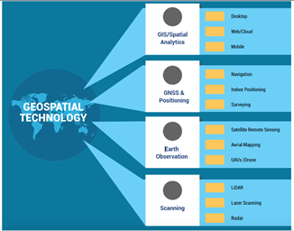
What is Geospatial Technology?
- Geospatial technology uses tools like GIS, GPS and Remote Sensing for geographic mapping and analysis.
- These tools capture spatial information about objects, events and phenomena (indexed to their geographical location on earth, geotag).
- The location data may be Static or Dynamic.
- Static location data include position of a road, an earthquake event or malnutrition among children in a particular region while dynamic location data include data related to a moving vehicle or pedestrian, the spread of an infectious disease etc.
- The technology may be used to create intelligent maps to help identify spatial patterns in large volumes of data.
- The technology facilitates decision making based on the importance and priority of scarce resources.