|
The Ministry of Environment, Forests and Climate Change (MoEFCC) released the India State of Forest Report (ISFR) 2021.
|
About the Report
- Published every two years: It is an assessment of India’s forest and tree cover, published every two years by the Forest Survey of India under the Ministry of Environment, Forests and Climate Change.
- The first survey was published in 1987: and ISFR 2021 is the 17th.
- The ISFR-2021 provides information on: forest cover, tree cover, mangrove cover, growing stock, carbon stock in India’s forests, forest fire monitoring, forest cover in tiger reserve areas, above ground estimates of biomass using SAR data and climate change hotspots in Indian forests.
- ISFR 2021 has some new features: It has for the first time assessed forest cover in tiger reserves, tiger corridors and the Gir forest which houses the Asiatic lion.
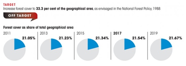
Targets
Key findings
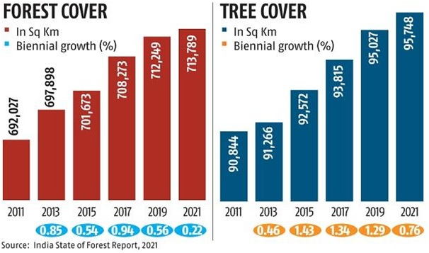
- Increase in forest cover: ISFR 2021 has found that the forest and tree cover in the country continues to increase with an additional cover of 1,540 square kilometres over the past two years.
- Tree cover has increased: India’s forest cover is now 7, 13,789 square kilometres, 21.71% of the country’s geographical area, an increase from 21.67% in 2019. Tree cover has increased by 721 sq km.
- Area-wise: Madhya Pradesh has the largest forest cover in the country followed by Arunachal Pradesh, Chhattisgarh, Odisha and Maharashtra.
- In terms of forest cover as percentage of total geographical area: the top five states are Mizoram (84.53 per cent), Arunachal Pradesh (79.33 per cent), Meghalaya (76.00 per cent), Manipur (74.34 per cent) and Nagaland (73.90 per cent).
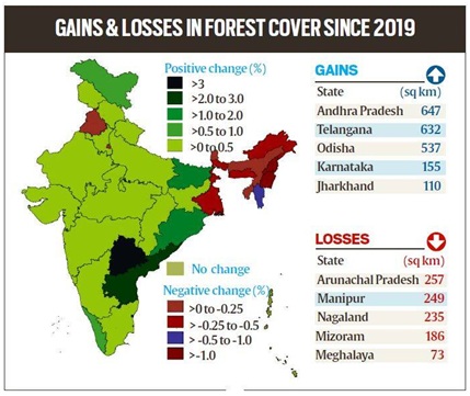
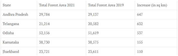
- The states that have shown the highest increase in forest cover: are Telangana (3.07%), Andhra Pradesh (2.22%) and Odisha (1.04%).
- Five states in the Northeast: Arunachal Pradesh, Manipur, Meghalaya, Mizoram and Nagaland have all shown loss in forest cover.
- Mangroves: have shown an increase of 17 sq km. India’s total mangrove cover is now 4,992 sq km.
- Top three states showing mangrove cover increase are Odisha (8 sq km) followed by Maharashtra (4 sq km) and Karnataka (3 sq km).
- Forest fires: The survey has found that 35.46 % of the forest cover is prone to forest fires. Out of this, 2.81 % is extremely prone, 7.85% is very highly prone and 11.51 % is highly prone
- The total carbon stock: in country’s forests is estimated at 7,204 million tonnes, an increase of 79.4 million tonnes since 2019.
- Bamboo forests: have grown from 13,882 million culms (stems) in 2019 to 53,336 million culms in 2021.
What is Forest Cover?
- The Forest Survey of India defines ‘forest cover’ as all lands of a hectare or more with tree patches with canopy density of more than 10 per cent, including green patches like orchards & plantations.
- These are outside ‘Recorded Forest Areas’ (RFA) which is land regarded as “forests” in govt records.
- This covers all lands, irrespective of legal ownership and land use. ‘Recorded forest area’ includes only those areas recorded as forests in government records and includes pristine forests.
|
State wise assessment
- A total of 17 states/union territories: have above 33 percent of the geographical area under forest cover. Out of these states and union territories, five namely Lakshadweep, Mizoram, Andaman & Nicobar Islands, Arunachal Pradesh and Meghalaya have more than 75 per cent forest cover.
- Twelve states and union territories: namely Manipur, Nagaland, Tripura, Goa, Kerala, Sikkim, Uttarakhand, Chhattisgarh, Dadra & Nagar Haveli and Daman & Diu, Assam, Odisha, have forest cover between 33 per cent to 75 per cent.
- Jammu and Kashmir: has lost very dense forests but gained open forests
- The total forest area of Himachal Pradesh: another mountainous state, has increased by 9 sq km.
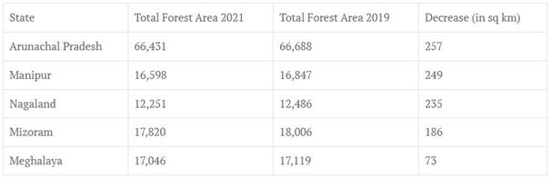
Five Indian states where total forest area has increased
Five Indian states where total forest area has decreased
What kind of forests are growing?
- Three categories of forests are surveyed:
- Very dense forests (canopy density over 70%),
- Moderately dense forests (40-70%) and
- Open forests (10-40%).
- Scrubs (canopy density less than 10%): are also surveyed but not categorised as forests.
- Scrub area has increased by 5,320 sq km – indicating the complete degradation of forests in these areas.
- Very dense forests: have increased by 501 sq km. This is a healthy sign but pertains to forests that are protected and reserve forests with active conservation activities.
- Experts say that what is worrying is a 1,582 sq km decline in moderately dense forests, or “natural forests”.
- Less dense open forests: The decline, in conjunction with an increase of 2,621 sq km in open forest areas shows a degradation of forests in the country with natural forests degrading to less dense open forests.
Reasons behind decline in the North-eastern states
- The Northeast states account: for 7.98% of total geographical area but 23.75% of total forest cover.
- The forest cover in the region has shown an overall decline of 1,020 sq km in forest cover.
- Largest forested areas: While states in the Northeast continue to have some of the largest forested areas, such as Mizoram (84.5% of its total geographical area is forests) or Arunachal Pradesh (79.3%), the two states have respectively lost 1.03% and 0.39% of their forest cover, while Manipur has lost 1.48 %, Meghalaya 0.43%, and Nagaland 1.88%.
- Environmental factors: The report has attributed the decline in the North-eastern states to a spate of natural calamities, particularly landslides and heavy rains, in the region as well as to anthropogenic activities such as shifting agriculture, pressure of developmental activities and felling of trees.
- This loss is of great concern as the North-eastern states are repositories of great biodiversity.
- Increase the impact of landslides: While natural calamities may have led to much of the loss, the declining forests will in turn increase the impact of landslides.
- It will also impact water catchment in the region: which is already seeing degradation of its water resources.
- Management issues: Unlike other states, where forests are clearly managed by the forest department and state governments, the North-eastern states follow a different ownership pattern community ownership and protected tribal land which makes conservation activities challenging.
The forest covers in tiger corridors
- It has increased: by 37.15 sq km (0.32%) between 2011-2021, but decreased by 22.6 sq km (0.04%) in tiger reserves.
- Forest cover has increased in 20 tiger reserves in these 10 years, and decreased in 32.
- Buxa, Anamalai and Indravati reserves: have shown an increase in forest cover while the highest losses have been found in Kawal, Bhadra and the Sunderbans reserves.
- Pakke Tiger Reserve in Arunachal Pradesh: has the highest forest cover, at nearly 97%.
- The Kanha to Navegaon-Nagzira-Tadoba-Indravati corridor: has the highest area under ‘Very Dense Forest’ comprising 857.65 sq km.
- The Kanha to Navegaon-Nagzira-Tadoba-Indravati tiger corridor that passes through Madhya Pradesh, Chhattisgarh and Maharashtra has the largest forest cover at 2,012.86 sq km.
- The Sundarbans Tiger Reserve: has the largest area under wetlands at 2,549.44 sq km. This means 96.76 per cent of its area is wetland.
- The Kanha Tiger Reserve has the highest number of wetlands at 461, most of which are less than 2.25 hectares (ha) in size.
- The Ranthambore-Kuno-Shivpuri-Madhav tiger corridor: in Rajasthan and Madhya Pradesh has the highest area under scrub at 15.68 sq km.
Issues/ Challenges
- Decline in forest cover in the Northeast: Experts have flagged some of its other aspects as causes for concern, such as a decline in forest cover in the Northeast, and a degradation of natural forests.
- Extreme rainfall may also increase in the states of the North East.
- Not a uniform trend: While ISFR 2021 has shown an increasing trend in forest cover overall, the trend is not uniform across all kinds of forests.
- Climate change: The report estimates that by 2030, 45-64% of forests in India will experience the effects of climate change and rising temperatures, and forests in all states (except Assam, Meghalaya, Tripura and Nagaland) will be highly vulnerable climate hot spots.
- Ladakh (forest cover 0.1-0.2%) is likely to be the most affected.
- Shifting trends: India’s forests are already showing shifting trends of vegetation types, such as Sikkim which has shown a shift in its vegetation pattern for 124 endemic species.
- Forest fire hotspots: In 2019-20, 1.2 lakh forest fire hotspots were detected which increased to 3.4 lakh in 2020-21.
- The highest numbers of fires were detected in Odisha, Madhya Pradesh and Chhattisgarh.
- According to the long-term trend analysis performed by the FSI, nearly 10.66 per cent area of forest cover in India is under extremely to very highly fire-prone zones.
- The survey results could be misleading as it includes plantations: such as coffee, coconuts or mango and other orchards – under forest cover.
- These plantations are distinctly different from natural forests where one hectare would be home to hundreds of species of trees, plants and fauna, whereas such plantations house only one species of tree.
- Decline in natural forests: Even though ‘very dense forests’ (with canopy density over 70 per cent) have increased by 501 sq km, 'moderately dense forests' or ‘natural forests’ (with 40-70 per cent canopy density) have declined by 1,582 sq km.
- Increase in temperature: It predicted that Himalayan states and UTs like Ladakh, Jammu and Kashmir, Himachal Pradesh and Uttarakhand will record the maximum increase in temperature and also possibly experience decrease in rainfall.
- It does not meet the objectives: The forest survey is carried out as an assessment of India’s biodiversity, but such an overarching survey does not meet that objective.
Some Governments Initiatives
- National Mission for a Green India: It is one of the eight Missions under the National Action Plan on Climate Change (NAPCC) with the objective to safeguard the biological resources of our nation and associated livelihoods against the peril of adverse climate change and to recognise the vital impact of forestry on ecological sustainability, biodiversity conservation and food-, water- and livelihood-security.
- National Afforestation Programme (NAP): It has been implemented since 2000 for the afforestation of degraded forest lands.
- Compensatory Afforestation Fund Management and Planning Authority, (CAMPA Funds): 90% of the fund is to be given to the states while 10% is to be retained by the Centre.
- The funds can be used for treatment of catchment areas, assisted natural generation, forest management, wildlife protection and management, relocation of villages from protected areas, managing human-wildlife conflicts etc.
|
Way forward
India is one of the few countries in the world: that brings out such in every two years, and this is widely considered comprehensive and robust.
With data computed through wall-to-wall mapping of India’s forest cover: through remote sensing techniques, the ISFR is used in planning and formulation of policies in forest management as well as forestry and agro forestry sectors.
Continuing increase: Despite so many issues, the report showed a continuing increase in forest cover across the country.