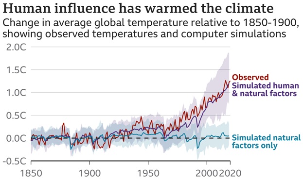
- Climate is the average weather in a place over many years. Climate change is a shift in those average conditions.
- The Earth is now in a period of rapid climate change, with global temperatures rising.
- When it comes to North East India, the climate is changing: Rainfall patterns over the region in the last century have considerably changed, resulting in its overall drying up.
- In the region, undulating terrain and lofty peaks provide natural lift to rain-bearing clouds from the Bay of Bengal to pour down in torrents. But rainfall trends in the past few years have just failed to convert.
- The North East India, which normally receives heavy rainfall during the monsoon months (June-September), has changed character for the worse.
- The flood-drought cycle now has begun to happen within a year, especially during the monsoon.
- The rains come in quick bursts and flood the region, followed by elongated dry periods that border on drought.
This brief aims to provide an in-depth analysis of the climatic situation of India’s north east.
Understanding geography of North-East Region (NER)
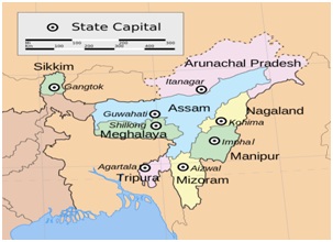
- The NER, which forms the easternmost border of India, comprises eight, largely hilly states – Arunachal Pradesh, Assam, Mizoram, Meghalaya, Manipur, Tripura, Sikkim and Nagaland.
- The region shares international borders of 5,812 km with the neighbouring countries of China, Bangladesh, Nepal, Bhutan and
- The landlocked NER is connected with mainland India by only the narrow 22-km-long Siliguri corridor, also known as the ‘chicken’s neck’, flanked by Nepal and Bangladesh.
| State |
Geography |
| Assam |
- The state is divided into three distinct geographical regions.
- North: Brahmaputra river valley at the foothills of the Himalayas
- South: Barak river valley
- In between the two valleys are Karbi Anglong and Cachar hills
|
| Arunachal Pradesh |
- The state has a significant forest cover of 82 per cent.
- It is mostly mountainous, and the only plains are in a thin band of land at the foothills bordering Assam.
- The forests cover the high hills in the south; snow covers the Himalayas to the north.
- All major tributaries of the Brahmaputra (Siang, Dibang, Subansiri and Lohit) come down from the mountains and fall into the plains of Assam at a steep gradient, making them prone to flooding.
|
| Nagaland |
- The state is mostly hilly with plains limited to a small portion bordering Assam.
- The state is drained by four major rivers and dozens of minor rivers and tributaries.
- Dhansiri, Doyang and Dikhu flow northward, down from the Naga hills into the Brahmaputra in Assam; the Tizu flows east towards Myanmar.
|
| Sikkim |
- The state is mostly mountainous with high hills, covered with evergreen forests in the south, and snow-capped Himalayan mountains towards the north.
- Teesta is the major river flowing through the state.
- It flows down into West Bengal before entering Bangladesh.
|
| Manipur |
- Only 10 per cent of Manipur is a valley while the rest is hills, divided between the eastern and western hills.
- Around a fourth of the valley area is covered with lakes, wetlands, barren lands and small hillocks, which leaves a small area for agriculture.
- The hills are either not cultivated much or people practice shifting jhum cultivation that is not very productive.
- The total area under cultivation is 7.4 per cent.
- Around 67 per cent of the population of the valley is engaged in agriculture, which puts extreme pressure on a small region to feed its entire population.
|
| Meghalaya |
- The state receives 71 per cent of its annual rainfall during the monsoon months.
- It has mostly hilly terrain with elevations with Khasi hills in centre, Jaintia hills in the east and Garo hills in west and some plain areas of low elevation.
- The state has physiographic variation with hills and plants / trees in the northern and western parts; in the south, the slopes are steep and regular with dense forest.
|
| Mizoram |
- The state is a land of rolling hills, rivers and valleys.
- There are 21 major hill ranges of different heights that run through the length and breadth of the state.
- They are mostly aligned in the south direction in parallel series and are separated by narrow deep rivers and valleys.
- The hills are extremely rugged and steep. There are some small patches of flat lands.
|
| Tripura |
- Tripura is a landlocked state with small hills and low-lying land with numerous deep rivers and valleys.
- The hills of the state run from north to south and parallel to one another till they disappear in the plains of Bangladesh.
- The hills are mostly of low elevation and are covered by thick forests.
|
The changing rainfall pattern
Rainfall
- Over the past century or so, rainfall in the region, along with the flood-drought cycle, seems to be changing character for the worse.
- The phenomenon has picked up pace in recent years.
- The flood-drought cycle now has begun to happen within a year, especially during the monsoon.
- The rains come in quick bursts and flood the region, followed by elongated dry periods that border on drought.
Other water source
- Other sources of water, such as glaciers that feed rivers in other mountain regions of India, are not as common in the North East.
- Glaciers in Arunachal Pradesh cover 223 square kilometres of a total land area (83,473 square km).
- The rain and snow feed mountain springs, which feed the tributaries that join either the Brahmaputra, Barak as well as rivers in Manipur. All these together water the region.
- If the rainfall decreases and the flow of the springs diminish, the rest of the water systems also get disturbed.
- Almost 27 per cent villages in northeast India are watered directly by the springs, according to a NITI Aayog report on the inventory and revival of springs published in August 2018.
- Around 70 per cent of the region’s area lay in the catchment of the Brahmaputra river and its major (41) and minor (121) tributaries as well as numerous streams.
- This dependency on rainfall makes the region highly vulnerable to climate change.
What are rainfall patterns in the region changing?
- An aspect of warming that influences rainfall is drying of the land, which increases the frequency and intensity of dry periods and droughts. An increase in moisture and the drying up together change the rainfall patterns in unpredictable ways.
- Excessive snowfall in Eurasia: Other climatic factors such as the increased snowfall in the Eurasian region also impact monsoon rainfall in North East India.
- Excessive snowfall in Eurasia cause cooling of the atmosphere of region, which triggers events leading to a weak summer monsoon season.
- A study in JGR Atmospheres attributed the decrease in rainfall to sea surface temperatures over the sub-tropical Pacific Ocean, which varies in a cycle and each phase of which lasts a decade. The peak comes every 20 years and is known as the Pacific Decadal Oscillation (PDO).
Impact of the changing pattern
- This changing rainfall pattern affects the-
- flow of rivers
- extent of snow cover and health of mountain springs, which in turn have an impact on
- livelihoods, especially agriculture and fishing
- forest flora growth
- animal and bird habitat (and behaviour) and other ecosystem aspects
- Land in the North East is naturally acidic because it receives heavy rainfall every year. Climate change-induced high frequency of heavy rainfall events will further exacerbate the acidification, which will decrease the quality of soil.
- Land degradation exacerbates other impacts of climate change too.
Why north-east is more vulnerable to climate change?
- Vulnerability is basically a function of sensitivity and adaptive capacity. All states in India are vulnerable to climate change as per our assessment. But these eastern and central states are more vulnerable because of their
- poverty levels
- lack of irrigation
- low forest cover in some cases
- low adaptive capacity of the health sector among other drivers
The overall situation of climate change in India
- In the last two years, India also had its share of several extreme weather events - be it
- cold waves in December 2019
- excess precipitation in North /north western regions
- drought like conditions in the North Eastern region in March 2020
- the world’s most devastating Cyclone Amphan in May 2020
- According to the Global Climate Risk Index 2021, India was the seventh most-affected country by the devastating impact of climate change globally in 2019.
|
Climate Change 2021: The Physical Science Basis
- The IPCC report titled ‘Climate Change 2021: The Physical Science Basis’ warned that India had to face irreversible impacts of climate crisis.
- The country can witness
- Glacial retreat in the Hindu Kush Himalayas
- compounding effects of sea-level rise and intense tropical cyclones leading to flooding
- erratic monsoon
- intense heat stress
|
What measures are required?
- Unless there are immediate and large-scale reductions in greenhouse gas emissions, limiting global warming to close to 1.5 degrees Celsius or even 2 degrees Celsius over pre-industrial times will be beyond reach.
- India needs to have more ambitious goals to tackle climate change. India is yet to announce its net-zero emissions target.
Is India ready for ‘net zero’?
- World's largest carbon emitter: China, the world's largest carbon emitter, has already announced it will be carbon neutral by 2060 and its emissions will peak before 2030 - although it has been criticised for building new coal plants.
- Second largest emitter: The US, the second largest emitter, has set 2050 as deadline to reach net zero and it says it will decarbonise its power sector by 2035.
- India: But the world's third-largest emitter India has neither announced the net zero year nor has it submitted to the UN an updated climate plan with raised carbon-reduction ambition, as required by the Paris agreement every five years.
|
Net zero means reducing greenhouse gas emissions as much as possible and then balancing out any further releases by absorbing an equivalent amount from the atmosphere - for instance, by planting trees.
|
Way forward
Going forward, the country is going to witness coastal flooding, rapid melting of glaciers in the Hindu Kush Himalaya regions, increase in frequency and severity of extreme heat waves and rise in annual mean precipitation underscoring the fragility of the Indian ecosystem.
Thus, it becomes crucial for India, the third largest emitter in the world, to adopt targets proactively to accelerate the transition to a low carbon economy. India must place itself at the centerstage of climate action by setting ambitious targets like Net Zero and establishing a robust policy environment to achieve them.